


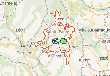

17.8 km | 27 km-effort


User


FREE GPS app for hiking
 SityTrail
IGN / Geographical institutes
SityTrail World
The world is yours!
Trail Walking of 22 km to be discovered at Auvergne-Rhône-Alpes, Rhône, Val d'Oingt. This trail is proposed by adye.
Au profit de l'association @Ta'vitae
Trail de la vigne en rose :
- parcours de 11kms | départ 18h00
- parcours de 21 kms | départ 17h00
-> inscription sur : https://www.chronopuces.fr/course.php?nom=trail-de-la-vigne-en-rose&id=111
Randonnée de la vigne en rose :
- parcours de 11kms | départ de 8h00 à 14h00
- parcours de 21 kms | départ de 8h00 à 11h00
-> inscription souhaitée sur : https://yurplan.com/event/Randonnee-La-vigne-en-rose/67642
Départs : Cave Coopérative - Saint-Laurent d'Oingt - 69620 Val d'Oingt
Au profit de l'association Ta'vitae (https://m.facebook.com/TaVitaeTarare/)
et avec les @Létraceurs
 "
data-pinterest-text="Pin it"
data-tweet-text="share on twitter"
data-facebook-share-url="https://www.sitytrail.com/en/trails/2826031-val-dxoingt--trail-x-rando-de-xla-vigne-en-rosexx--21-kms-x-14x07x2021/?photo=1#lg=1&slide=1"
data-twitter-share-url="https://www.sitytrail.com/en/trails/2826031-val-dxoingt--trail-x-rando-de-xla-vigne-en-rosexx--21-kms-x-14x07x2021/?photo=1#lg=1&slide=1"
data-googleplus-share-url="https://www.sitytrail.com/en/trails/2826031-val-dxoingt--trail-x-rando-de-xla-vigne-en-rosexx--21-kms-x-14x07x2021/?photo=1#lg=1&slide=1"
data-pinterest-share-url="https://www.sitytrail.com/en/trails/2826031-val-dxoingt--trail-x-rando-de-xla-vigne-en-rosexx--21-kms-x-14x07x2021/?photo=1#lg=1&slide=1">
"
data-pinterest-text="Pin it"
data-tweet-text="share on twitter"
data-facebook-share-url="https://www.sitytrail.com/en/trails/2826031-val-dxoingt--trail-x-rando-de-xla-vigne-en-rosexx--21-kms-x-14x07x2021/?photo=1#lg=1&slide=1"
data-twitter-share-url="https://www.sitytrail.com/en/trails/2826031-val-dxoingt--trail-x-rando-de-xla-vigne-en-rosexx--21-kms-x-14x07x2021/?photo=1#lg=1&slide=1"
data-googleplus-share-url="https://www.sitytrail.com/en/trails/2826031-val-dxoingt--trail-x-rando-de-xla-vigne-en-rosexx--21-kms-x-14x07x2021/?photo=1#lg=1&slide=1"
data-pinterest-share-url="https://www.sitytrail.com/en/trails/2826031-val-dxoingt--trail-x-rando-de-xla-vigne-en-rosexx--21-kms-x-14x07x2021/?photo=1#lg=1&slide=1">
 "
data-pinterest-text="Pin it"
data-tweet-text="share on twitter"
data-facebook-share-url="https://www.sitytrail.com/en/trails/2826031-val-dxoingt--trail-x-rando-de-xla-vigne-en-rosexx--21-kms-x-14x07x2021/?photo=2#lg=1&slide=2"
data-twitter-share-url="https://www.sitytrail.com/en/trails/2826031-val-dxoingt--trail-x-rando-de-xla-vigne-en-rosexx--21-kms-x-14x07x2021/?photo=2#lg=1&slide=2"
data-googleplus-share-url="https://www.sitytrail.com/en/trails/2826031-val-dxoingt--trail-x-rando-de-xla-vigne-en-rosexx--21-kms-x-14x07x2021/?photo=2#lg=1&slide=2"
data-pinterest-share-url="https://www.sitytrail.com/en/trails/2826031-val-dxoingt--trail-x-rando-de-xla-vigne-en-rosexx--21-kms-x-14x07x2021/?photo=2#lg=1&slide=2">
"
data-pinterest-text="Pin it"
data-tweet-text="share on twitter"
data-facebook-share-url="https://www.sitytrail.com/en/trails/2826031-val-dxoingt--trail-x-rando-de-xla-vigne-en-rosexx--21-kms-x-14x07x2021/?photo=2#lg=1&slide=2"
data-twitter-share-url="https://www.sitytrail.com/en/trails/2826031-val-dxoingt--trail-x-rando-de-xla-vigne-en-rosexx--21-kms-x-14x07x2021/?photo=2#lg=1&slide=2"
data-googleplus-share-url="https://www.sitytrail.com/en/trails/2826031-val-dxoingt--trail-x-rando-de-xla-vigne-en-rosexx--21-kms-x-14x07x2021/?photo=2#lg=1&slide=2"
data-pinterest-share-url="https://www.sitytrail.com/en/trails/2826031-val-dxoingt--trail-x-rando-de-xla-vigne-en-rosexx--21-kms-x-14x07x2021/?photo=2#lg=1&slide=2">

Walking

Walking

Walking
On foot

Nordic walking

Electric bike
Walking
Walking
Walking